Abercorn to Ponto do Ouro
Jeremy Wafer
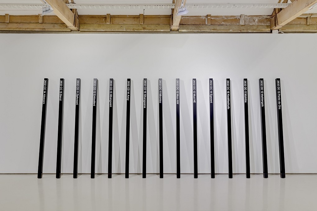
Abercorn to Ponto do Ouro, 2002
Timber with vinyl
Work (each): 237 x 10 x 10 cm
Abercorn to Ponto do Ouro, 2002; 15 elements each 2.5m x 10 x 10cm; vinyl lettering, paint, version 1 hardboard; version 2 aluminium; first exhibited: Vita Art Awards, Goodman Gallery, Johannesburg 2002; collection: the artist. This work, which came out of a long series which has been interested in exploring the ways in which land is claimed, owned, demarcated, and controlled, was part of a related set of works on the Vita exhibition using aerial photographs and mapping (1) of the border between South Africa and Mozambique. The border, which runs between Swaziland and the Indian Ocean, which consisted both of a fence flanked by a wide band of planted sisal and a straight line on a map, is explored as both a political and geographical barrier and as a reference to a more personal condition with associations of inclusion and exclusion, of safety and threat, of desire and denial, of self and other which do relate in important ways to my own history and psychology but on a more public level to the experience shared with many of my class and generation of military conscription on “the border”. (2) The work was made not by visiting the site, but through the use of large scale aerial survey photographs and maps acquired from the Surveyor General. (3) This procedure seemed an appropriate embodiment of the notions of separation and alienation I was working with. At the same time, I was conscious of the resonance of the words Ponto do Oro, a place I have not visited but which seemed evocative, on a more poetic level, of a desire for a something else beyond the aridity of a repressive politic. The notations on the black staffs refer to the 1:50 000 scale map grid of South Africa, the sections and subsections of which are numerically sequenced and allocated names. These include, for this section of territory, running from east to west: Abercorn on the Swaziland border, then Banzi, Ziphoseni, Embadleni, Mbangweni, Ancy, Sihangwano, Mboniso, Muzi NW, Muzi NE, Egezeni, KwaMahudu, Mzimba, Mahlungulu until Ponto do Oro on the coast: a litany of place and separation. 1) Adjacent to this work was a wall installation consisting of vinyl numbers reflecting the elevation above sea level of various points following the topographical map of the area. Previous work includes a line of standard 1:10000 orthophoto maps of the same border and a large scale digital print of a section of the border with the border line running through the centre. The most recent iteration is a smaller digital print of the aerial photograph of the Ponto do Ouro border post with accompanying text on my 2022 exhibition at Goodman London. 2) I was conscripted for two 3 month periods of military duty on what was then the northern South West African border in 1976 and 1977 where I worked as an intelligence clerk updating maps. 3) The Surveyor General in Cape Town and Pretoria carries a full set of maps and aerial survey material covering South Africa and some adjacent territories.